

Met Office: Storm Gerrit brings strong winds and heavy rain to the north and north-east
Register for free to read more of the latest local news. It's easy and will only take a moment.

Storm Gerrit will bring strong winds and heavy rain to many parts of the UK on Wednesday, with wintry hazards also likely, especially across northern Scotland.
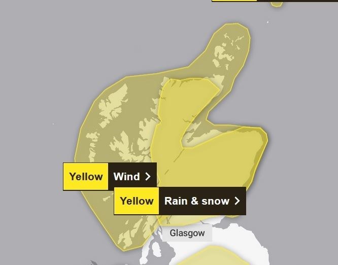
A number of weather warnings have been issued by the Met Office including a yellow warning for Grampian for the whole of Wednesday for rain, snow and high winds.
A band of heavy rain and hill snow will move north-east across Scotland on Wednesday.
At low elevations (roughly below 200 metres) this will fall mostly as rain, with 20-30 mm quite widely and perhaps as much as 50-70 mm in some locations.
t higher elevations (roughly above 200 to 300 metres) snow is expected, with 10-15 cm likely to accumulate, particularly on southeast-facing hills, affecting some higher transport routes.
Additionally very strong south-easterly winds will accompany the rain and snow, leading to blizzard conditions on the highest routes, and perhaps also ice build-up on some power lines and other structures over high ground.
A separate wind warning is in force for much of this area-
Strong east or south-easterly winds will affect the warning area during Wednesday. Initially developing in the south of the region, these strong winds will gradually spread further north, becoming confined to Orkney by the end of the day.
Over the south of the warning area gusts are likely to reach 50-60 mph, especially along coasts and to the west of high ground, and perhaps as high as 70 mph in a few locations.
The winds are expected to strengthen as they spread across the north of the warning area, with gusts reaching 60-70 mph widely and perhaps as much as 80 mph along some northern coasts.
Winds will be particularly gusty across and to the west of high ground.
Conditions should improve across the south of the warning area by mid-afternoon and then across north Highland during the evening.
Met Office Chief Meteorologist Frank Saunders said: “Storm Gerrit will run towards western UK on Wednesday and bring with it potential impacts for much of the UK.
“Winds across southern coastal areas of England will be strong, possibly peaking around 70 mph on exposed coastlines, but more widely around 50-60 mph within the warning area.
“Rain is an additional hazard from Storm Gerrit, with active weather fronts leading to a wet day for many. Snow is also likely to cause problems for some northern areas: only briefly for a few upland routes across the Pennines and southern Scotland overnight and early on Wednesday, but more widely to the north of the Central Lowlands later in the day.
"Here around 10 to possibly 20cm of snow may affect some of the highest routes, this combining with very strong winds to lead to some difficult travel conditions.
"At lower levels a combination of heavy rain and very strong winds will dominate.”