

Chance to see Northern Lights before thunderstorms bring end to fine weather
Register for free to read more of the latest local news. It's easy and will only take a moment.
Clear skies will offer stargazers a chance to see the Northern Lights at the start of this weekend but thunderstorms are expected to bring an end to the nice weather on Sunday.
Forecasters said the UK recorded its highest temperature of the year on Thursday, with a peak of 24.6C in London’s St James’s Park, and it is set to get hotter.
Highs of 26C are predicted for the South East on Saturday with the possibility of temperatures rising to 27C on Sunday, but there is also the potential for intense rainfall.
Met Office spokesman Stephen Dixon said Friday night’s skies will offer a chance for the Northern Lights to be seen.
He said: “Although the shorter nights will limit the visibility window, there’s a good chance to see the aurora, particularly on Friday night and especially in Scotland, Ireland and parts of northern England and Wales.
“There could even be visibility further south if you have the right equipment.
“Those conditions could continue on Saturday night but we still have to work out some details on where exactly that will be.”
Mr Dixon said the combination of clear skies and enhanced activity from the sun reaching Earth would improve the chances of seeing the display.
On Saturday, the vast majority of the UK is expected to see dry and sunny weather with temperatures above average for the time of year, he said.
But the fine weather is not expected to last.
Mr Dixon said: “There is a change on the way. Sunday could well be the warmest day, despite a more unsettled period.”
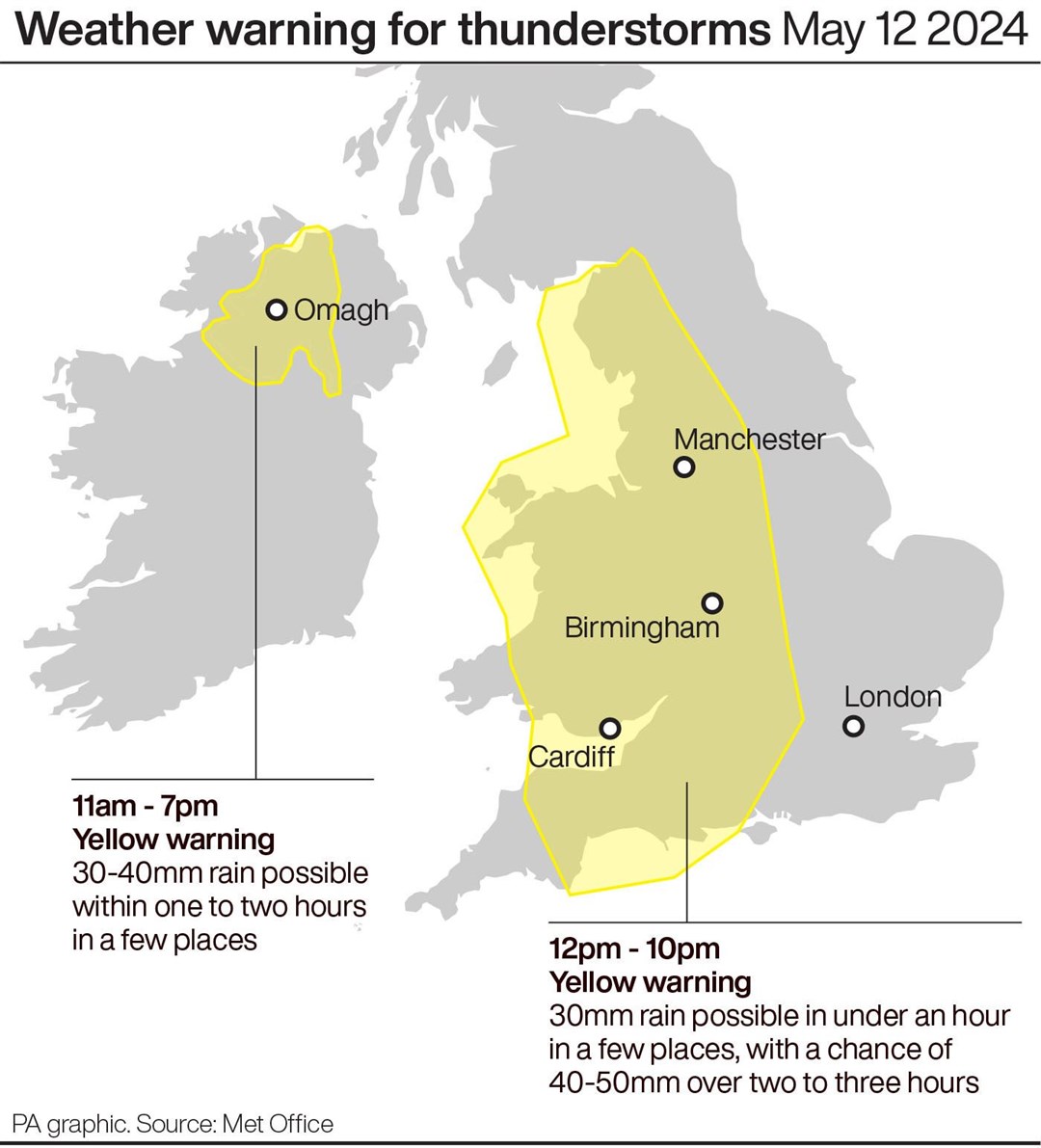
Two yellow weather warnings are in place for thunderstorms on Sunday – one for western parts of Northern Ireland from 11am until 7pm and the other covering a large part of England and Wales from 12pm until 10pm.
Mr Dixon said: “There is the potential for travel disruption and rainfall events as part of the thundery systems. Some intense downpours are possible, with the potential for up to 30mm of rain in less than an hour or 40-50mm over a couple of hours, which could lead to surface water issues.
“As we move into next week it’s looking like a return to an unsettled period of weather for the UK with frequent rain through the early part of next week.”