

Flood and rain warnings issued as weather builds to ‘nasty storm’
Register for free to read more of the latest local news. It's easy and will only take a moment.
Heavy rain is being forecast overnight for several parts of the country as wet and windy weather is expected to build up to a “nasty storm” later in the week.
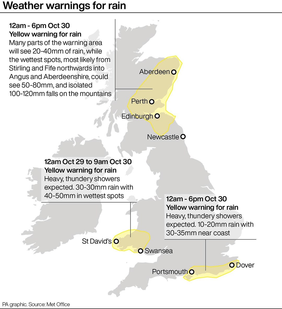
The Environment Agency has issued 72 flood warnings as the latest band of bad weather approaches leading up to the next storm on Wednesday night which has been give named Storm Ciaran.
And the Met Office has yellow warnings for rain in place for south Wales, south east England and eastern Scotland down to Newcastle for Sunday.
A further warning is in place for Northern Ireland for Monday.
The forecaster advises the latest rains could lead to disruption to roads and public transport and even lead to a “danger to life” from floodwater in Scotland.
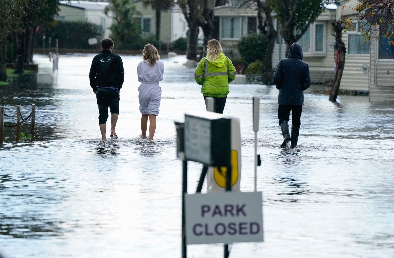
Flooding was seen across Sussex during the weekend including the Priory Meadow Shopping Centre in Hastings which was evacuated on Saturday with people posting on social media showing deep floodwater coming through the entrance.
On Sunday, a caravan park in Bognor Regis was also underwater with the town’s Tesco supermarket car park flooded while a house had its roof ripped off in heavy winds that residents described as like a “tornado”.
Marco Petagna, a Met Office meteorologist, said: “We’ve had various warnings in force across the UK over the last few days and there are plenty more being issued for the next couple of days.
“The main focus in the next day or two is towards the east of Scotland, north-east England where there is a yellow rain warning until 3am.
“There will be persistent rain up there and then the focus for heavy showers will be across parts of southern and south eastern England, south Wales as well parts of Northern Ireland with some heavy and sudden showers as well.”
He said that Tuesday was expected to be still unsettled but quieter before heavy winds and longer spells of rain develop on Wednesday night into Thursday as Storm Ciaran arrives.
He said: “There are possible gusts of 80 to 90 miles an hour in some exposed southern areas. It’s probably quite a nasty storm this one.”
Kate Marks, flood duty manager at the Environment Agency, said: “We urge people to stay safe on the coast and to remember to take extreme care on coastal paths and promenades. Flooding of low-lying coastal roads is also possible and people must avoid driving through flood water, as just 30cm of flowing water is enough to move your car.
“People should check their flood risk, sign up for free flood warnings and keep up to date with the latest situation at https://www.gov.uk/check-if-youre-at-risk-of-flooding and follow @EnvAgency on X, formerly known as Twitter, for the latest flood updates.”

The weather is expected to worsen as the week progresses with rain warnings in place until Wednesday with a “deep area of low pressure” set to arrive on Thursday which has been named by the Met Office as Storm Ciaran which will bring strong winds and heavy rain to southern parts of England and Wales.
Met Office Deputy chief meteorologist Chris Almond said: “Winds associated with Storm Ciaran are likely to gust to 80mph along the south coast of England, with a small risk of somewhere exposed seeing 90 mph, and winds could even gust up to 50 or 60 mph further inland.
“This deep, low-pressure system will also bring heavy rain to much of the UK, but the heaviest rain is expected in southern and western areas with 20 to 25 mm quite widely across the region but up to 40 to 60 mm potentially over higher ground.
“Heavy and persistent rain will fall on to already saturated ground bringing a risk of further impacts such as flooding in areas that are already struggling to clean up from the heavy rainfall we have seen over the last week or so.”